METRO JAVA 2045
BACKGROUND + OUTLINE
Java, the world’s most populated island, has long evaded planning conventions. Today, Java Island is a harbinger of emergent rural-urban amalgamations that demand new geospatial tools and strategies.
Metro Java 2045 is a three-tiered project that sets out to develop new methods of analysis and planning for peri-urban territories. It departs from the observation that the planning models which urban theory prescribes (i.e. compact, integrated, collaborative, scenario-based), are hardly ever applied in rapidly urbanizing regions, such as Indonesia. Under pressure, urbanization falls apart into formal schemes of large, isolated projects, and piecemeal, informal expansion. This schism is the product of urgency, a siloed planning culture, and a lack of capacity on the ground. But it also reflects a structural problem of planning itself: overarching strategies fail to give agency to grassroots initiatives.
WHY? PREMISE
In emerging economies this inability is augmented by a lack of understanding. As cities fuse with the countryside without much oversight, muddled peri-urban landscapes form, characterized by stretched out networks, blurred edges, and program in a permanent state of mixture. We strategize, but without the right tools to interpret the complex geographies at a granular level. GIS software is improving rapidly, but still fails to provide local stakeholders with actionable information. The gaps between policy goals and the informal patterns of in situ urbanism widen.
Java is a prime example of a rapidly changing landscape that defies conventional planning. Java is the world’s most populated island. At twice the size of the Benelux, it accommodates five times the population, or 150M people. It is also the fastest urbanizing region. This make Java a harbinger of a burgeoning global condition: vast, but dense peri-urban territories, where natural hazards, climate change, and urban-industrial expansion all mount pressure on fragile ecologies and agricultural systems.
Metro Java 2045 sets out to tackle this challenge in three stages: 1. developing a tool for spatial analysis of land use patterns, 2. applying this data to develop a multi-stakeholder planning strategy, 3. implementation of this strategy on select pilot sites.
These ambitious goals are tailored to formulate a new planning methodology from the ground up. The project starts from the premise that land use integration is the foundation of sustainable planning. The new GIS-tool can trace severely fragmented program and cluster it intelligently to reveal larger patterns. This opens up new avenues of cross-scalar planning that assist local communities to preserve natural ecologies and Java’s unique rural-urban system, the Desakota. The project will generate many maps, analyses, and strategies that explore and evaluate new modes of integrated planning, both for Java and far beyond.


Fluid and dispersed, the peri-urban landscape is definition resistant. In the absence of adequate spatial and conceptual delineation, any form of suburbanization, such as the rapid expansion of Indonesia's Extended Metropolitan Regions (EMR) is easily miscategorized as a peri-urban landscape. The peri-urban landscape, however, is not likely to evolve into well-integrated urban fabric. The desakota, as a specific subset—defined by densely populated, yet tightly organized agrarian communities with a strong cultural and historical foundation—can offer new insights into alternative futures for peri-urbanity.
The desakota introduces a number of common opportunities and challenges. Their planning remains hampered, as the desakota spills across administrative borders and different departments have different planning priorities (McGee 2005). Traditionally, cooperation between different authorities, from the central government, to institutional bodies managing resources and infrastructure, down to the traditional village (adat), is limited. As urbanization accelerates, city management instruments become increasingly insufficient (Setiawan 2020). These urgencies give rise to crude, instant solutions. Yet, we believe that now the desakota is granted new mandates, it can become a backbone for strategies that can bridge the schisms.
Previous studies by the initiators of Metro Java 2045 have explored the promise of the desakota as a green hybrid typology (project protoTamansari, Java, Indonesia, Krill et al.). Conversely, we mapped their risks as a landscape that tends to quickly absorb the residual program rejected by the urban centers, on which they have become economically reliant (The Chinese Dream, MARS architects / Dynamic City Foundation). Both projects have mapped the same spatial condition at two different points along their developmental arc. Despite village footprints remaining compact, below the radar China’s rural landscape has seen a progressive deterioration, which now we anticipate for Java. It highlights the importance to plan peri-urban landscapes within temporal and integrated frameworks. Metro Java 2045 sets out to formulate an action plan that can guide the transformations of the desakotas, looking at the year 2045. This is when Indonesia will celebrate its centennial, and Java aims to complete the profound urban, industrial, infrastructural and rural overhaul that is now being planned.
Metro Java 2045 responds to two new regulatory realities that will have a profound, but uncertain impact on the landscape:
National toll roads are being planned that offer local districts a mandate for “land value capture”, where exit ramps and tertiary roads create investment opportunities.
Increased regional autonomy and fiscal decentralization policies give village administrations a mandate to take charge in their urbanization and renewal process.
Java’s administrators have fervently embraced the potential of new infrastructure to generate economic development, yet the impact of heavy conduits dissecting the land and spawning in situ urbanization is not sufficiently investigated. Greater village level autonomy can tackle poverty, but up-to-date spatial information is scarce and enforcement of strategic planning is rare. Meanwhile, poor coordination among villages leads to unproductive competition and landscape fragmentation.
However, Metro Java 2045 posits that taken together, these two regulatory changes can open the door to an overarching, yet pragmatic spatial strategy. A cluster-based land use analysis can reveal how regional functional patterns may be optimized. While network analyses of Java’s infrastructure can pinpoint how, at village level, this strategy can be actualized. This delivers Metro Java 2045 its premise:
Contiguousness of (red, green, blue) land use clusters provides an holistic benchmark for planning integration.
A whole systems approach to Java’s burgeoning infra-network (from tollways to rural lanes) allows for a cross-scalar strategy to be formulated that connects regional land use objectives to village-level planning initiatives.
An online platform can help villages to better align their ambitions with the features of their surroundings and with the villages in their cluster, thus strengthening the fine networks of Java's desakota landscapes bottom-up.
HOW? CLUSTERS
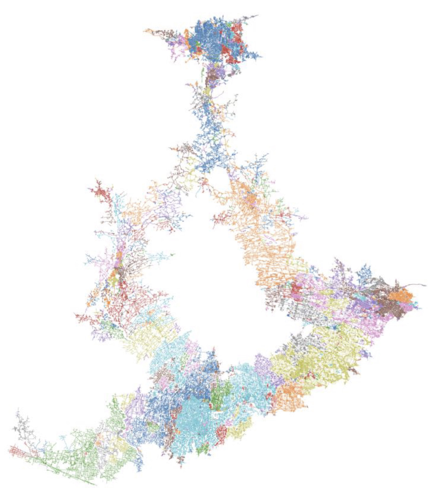
Urbanism has a blindspot that permeates from policy to practice: its maps space either with vectors or pixels. Vector maps divide the landscape into precise but rigid regions, when muddled peri-urban landscapes underscore the limitations of this method. Strategic plans collapse along political boundaries and stale departmental silos. The cluster method can begin to bridge both mapping methods, revealing territories structured around spatial issues, rather than political borders. This opens the process up to site specific collaborations and strategic alliances. By observing land use clusters across scales, Metro Java 2045 connects regional plans to action plans.
WHERE? FIELD WORK
Within the context of rapidly urbanizing markets, having defined a research and planning methodology is not enough. A staunch dichotomy—of urgent construction for prosperity, versus a long-term preservation-oriented growth strategy—shapes the decision making process, whereby strategies that deliver fast return on investment most often prevail over more complicated, integrated and gradual approaches.
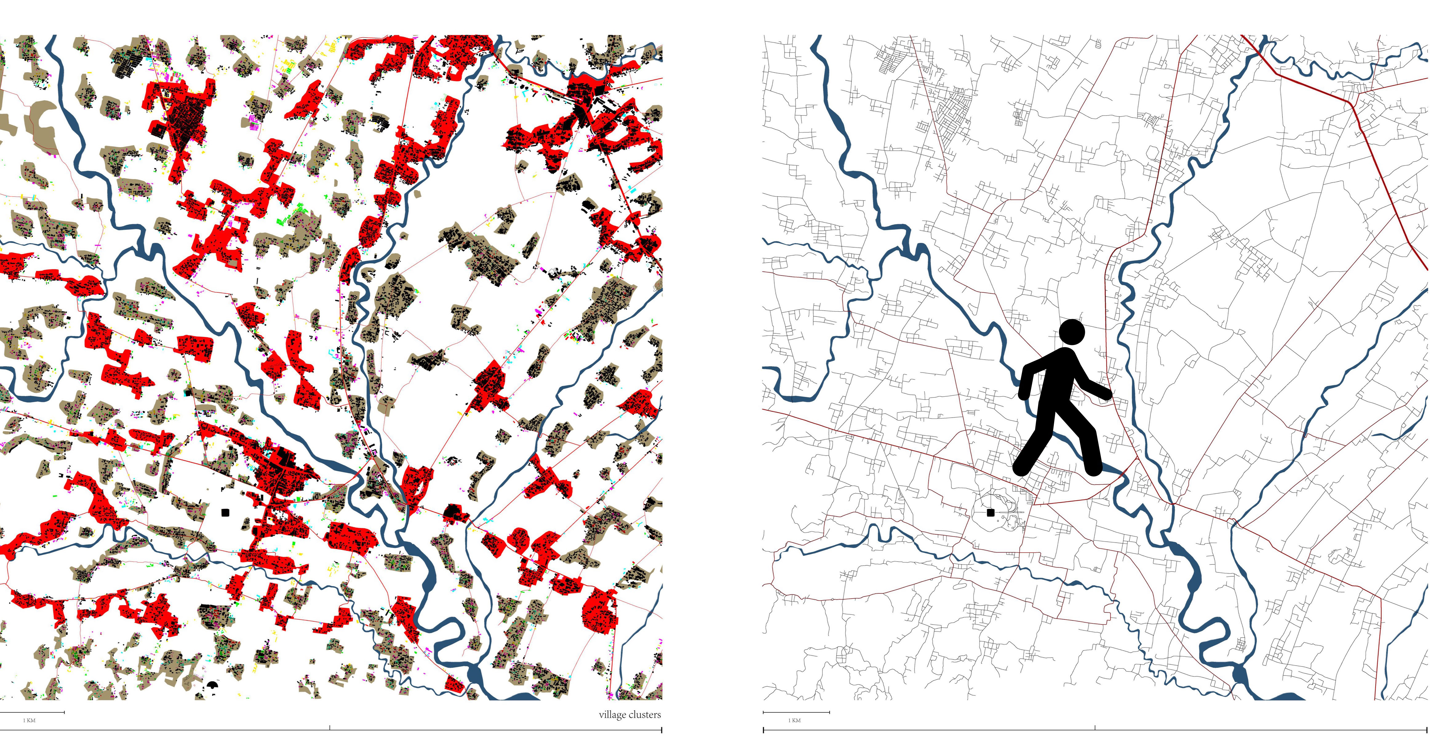
Therefore, field work is pivotal to bridge theory and practice; finding stakeholders, evaluating pilot sites and guiding the process. Earlier studies (Allen 2003) have concluded that peri-urban development tend to succeed only when they are issue specific, rather than generic, and organized in multi-disciplinary collaborations. In a context where the municipal workforce is too small to sustain proper enforcement of zoning laws, urban development is mostly “affordance driven”, in other words, shaped by what is possible, rather than by what is legal. The affordances of a region are a set of drivers that can range from natural hazards, job and investment opportunities. In such a context, development is a product of all stakeholders being shaped by enabling (and disabling) mechanisms. Instead of a large, rigid masterplan, drafted from afar, the peri-urban landscape tends to be best planned through carefully chosen, acupuncture-like interventions. Therefore, armed with our red-green-blue cluster maps, we will set out to identify the precise desakota subtypes within the main clusters. This catalogue of congruent sites is shared online. Their commonalities allow for a catalogue of solutions to be crafted for all desakota subtypes.
WHO? ALLIANCES
Rural-urban landscapes, like the desakota present challenges that lie well beyond the realm of urbanism and urbanists. This does not, however, diminish the role of the planner, but instead puts us at the center of a network of related disciplines—from smart technologies to community activism. In this capacity, the planner must be retooled as a mediator, operating across scales and between stakeholders, to connect urgency to opportunity.
This process relies on advancements in planning theory, GIS technology and international and local knowledge exchange. The core team consists of two Indonesian and two Dutch experts: professor Bakti Setiawan from the UG University and Dr. Wiwandari Handayani from UNDIP-university, and project initiators Dr. Neville Mars and Ir. Harmen van de Wal.
The extended project team brings together geographers, data scientist and coders, to develop new maps, analyses and tools, but also consists of local planners, architects, and policy experts —from hereon together referred to as the “Think Tank”—that can translate the analyses and proposal into practical steps.
Metro Java 2045 is an island-wide strategy, but the project is focussed on integrating the peri-urban hinterland. Therefore, success will rely on building broad alliances, specifically, in areas where the desakota intersects with Indonesia’s “Extended Metropolitan Regions”, and its expanding highway network and industrial zones. Here, we see opportunities to collaborate with a number of government and knowledge institutions that are developing planning strategies for Java.
We’ve built a network of affiliates and scholars working at leading institutes, including RMIT, Gajah Mada University, UNDIP, Universiteit Wageningen, IHS, Deltares, the Ministry of Public Works, Ministry of Agrarian affairs and Spatial Planning, Ministry of Villages, and Ministry of Environment and Forestry.
In the coming phase we will reach out to other teams in the region. Notably, ETHs Future City’s Lab, The Desakota Study Team, Indonesian scholars at ITB, the planning department of Gajah Mada University in Yogyakarta, the Peri-urban Interface program at UCL, and the EU Strategic Environmental Planning.
DOWNLOAD OUR TWO AWARD WINNING PAPERS ON NETWORK ANALYSIS AND CLUSTER ANALYSIS IN CENTRAL JAVA.
WHAT, WHEN?
With the financial support from the EFL-foundation and co-financing by the team members, we have been able to complete a ‘phase 0’ feasibility study. We’ve charted the road ahead, including potential planning hurdles, technical challenges, data availability and how to achieve lasting local commitment.
Phase I: Research & Development.
Dec 2020 - 1 Jun 2021
Phase I pertains to two parallel tasks: research and development. Development (budget item 1a2) pertains the scripting of a geospatial tool that can at once trace red, green, and blue land use types and cluster these intelligently across scales—previews of the initial modeling trials from the feasibility study are included on pages 7, 8, 11.
The GIS technology can quickly render detailed islandwide maps, deliver network analyses (p.8), and chart natural hazards, manmade ecological impact, and catchment area of streams and rivers. However, as indicated, Java’s dynamic urbanization cannot be captured by using big data alone. Beyond geographic features, its landscape will also be forged by socioeconomic forces and fields of seemingly immaterial ‘affordances’.
The research component of phase I pertains to the collecting of narratives (budget item Ia3-5), which describe grassroots mechanisms of enabling/disabling, obtained through drones footage, interviews and site surveys—scoping irrigational systems, agricultural output, formal and informal services and industries, local densities, FARs and building typologies, and micro demographic and mobility trends.
Together, the research of Phase I delivers a catalogue of desakota subtypes, presented in the first report (Ia7). This investigation of land types allows us to build a catalogue of site specific solutions.
The ONE HOUR CITY


Key findings
The transformation of Java’s heritage landscape is more ambiguous than we imagined. A diverse set of socio-spatial drivers impact the landscape in subtle but pernicious ways. On the one hand, this suggests the project is timely and
can still effect real change. On the other hand, we anticipate that many of the transformations (road proliferation, industrialisation, climate change, a.o.) will amplify each other, exacerbating the depletion of the desakota towards 2045.
The role of the village is at the heart of these transformations. A new mandate village leadership has been granted in shaping their spatial context, due to the implemention of a huge decentralization process, could either accelerate ongoing deterioration, or provide the key to integrating top-down and bottom-up development trends. The piecemeal development of individual villages fuels economic growth, yet defies any careful spatial orchestration of the larger region. Conversely, large, centrally planned public works, which bring economic opportunity, also erode the productive landscape. As the smallest administrative unit, transformations at the village level underscore the importance of a cross-scalar, multidisciplinary planning approach. Such an attempt at planning integration is almost destined to fail in the Indonesian context. Decentralization of power goes hand in hand with horizontal segregation of organization into separate departments. An empirical approach, generating a range of seemingly unrelated outcomes, is therefore hard to consolidate into a comprehensive planning strategy. Based on our initial findings we have refined the overall methodology. Rather than attempting to create comprehensive master plans, we are using comprehensive analysis and transparency. Drivers for urban transformation and fragmentation will defined with one important objective: to find levers influencing the developments. In complex bureaucratic planning environments, the simplest of tools will be most effective. The preindustrial desakota is assumed as benchmark for future development. GIS cluster analysis and network analysis are applied to calculate contiguousness for different scenarios. By tracing the landscape topography and intersecting with the local watersheds, we have divided Central Java into around 30 plots, each presenting a unique land use type, or ‘module’. In parallel, across these modules dozens of sample points are mapped at the micro level. This accuracy allows us to certify the outcomes from the data analyses, and more importantly, allows us to interpret what socio-spatial drivers underly the transformations and what significant qualities each specific land use module pertains. These site specific challenges and qualities provide a foundation for ensuing collaborative strategies. Moving forward, these findings are packaged to inform an expert forum end of August and a stakeholder workshop
mid September 2021. The feedback garnered in these workshops is the starting point to develop actionable schemes for the different land use modules, starting with the Borobudur region October 1, 2021.
Owned by neville mars / Added by neville mars / 14.9 years ago / 120917 hits / 3 hours view time
Latest Entries
Contribute
Login to post an entry to this node.
